
By
Anna Skinner is a Newsweek senior reporter based in Indianapolis. Her focus is reporting on the climate, environment and weather but she also reports on other topics for the National News Team. She has covered climate change and natural disasters extensively. Anna joined Newsweek in 2022 from Current Publishing, a local weekly central Indiana newspaper where she worked as a managing editor. She was a 2021 finalist for the Indy’s Best & Brightest award in the media, entertainment and sports category. You can get in touch with Anna by emailing a.skinner@newsweek.com. Languages: English.
Anna Skinner
Senior Reporter
🎙️ Voice is AI-generated. Inconsistencies may occur.
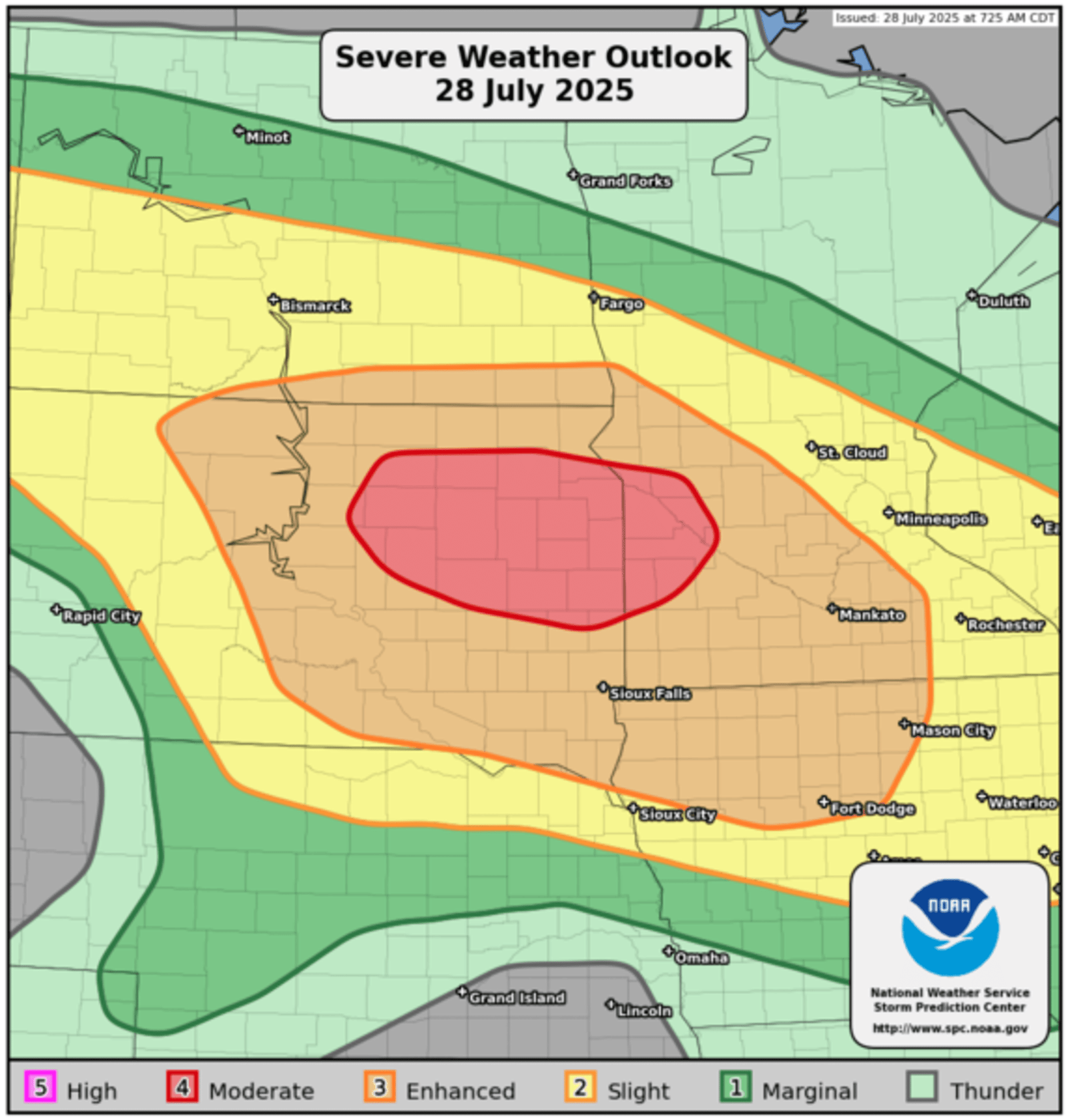
There is at least a marginal risk of severe thunderstorms accompanied by hurricane-force winds to impact a widespread portion of the northern Plains on Monday, with the chances of such storms expected to be particularly high for two states.
Why It Matters
Severe thunderstorms were forecast to impact parts of the northern Plains on Monday, with damaging winds that could reach hurricane strength, although the storms are not tropical in nature. People in at least two states faced a combination of damaging storms, possible tornadoes and flooding risk, underlining the importance of preparedness and vigilance during peak summer storm periods.
NWS Storm Prediction Center
What To Know
The National Weather Service (NWS) Storm Prediction Center issued a severe weather outlook early Monday morning warning of widespread damaging winds, including some gusts expected to reach or exceed 75 mph—qualifying as hurricane force—across eastern South Dakota and southwest Minnesota later in the day and overnight.
Even larger portions of both states, as well as parts of Iowa, North Dakota and Nebraska, are expecting a slight or enhanced risk for similar storms on Monday.
In addition to these potentially destructive winds, forecasters anticipated a risk of a few tornadoes and isolated large hail in the region. The outlook also noted that widely scattered storms capable of severe wind and hail could develop across portions of Montana.
Severe thunderstorm warnings were already in place for eastern Montana and western North Dakota on Monday morning, with the risk expected to persist throughout the day.
In addition to the severe thunderstorm warnings, severe thunderstorm watches, severe weather statements and hazardous weather outlooks also were in place across the northern Plains on Monday morning.
What People Are Saying
NWS Storm Prediction Center meteorologist Andrew Lyons told Newsweek: “This is pretty common to get occasional days where you have a line of really strong thunderstorms around this part of the country. We usually issue them one or two times per year around this time of year.”
A severe thunderstorm warning for the Bismarck, North Dakota, region: “These storms have a history of producing severe wind gusts in excess of 60 mph. For your protection, move to an interior room on the lowest floor of a building, and stay away from windows.”
A severe weather statement for the Billings, Montana, region: “Seek shelter inside a well-built structure and stay away from windows. This storm is capable of producing damaging winds and large hail.”
What Happens Next
The severe thunderstorm threat in the northern Plains was expected to continue through Monday night, with eastern South Dakota and southwest Minnesota urged to monitor real-time warnings and take shelter when advisories are issued. If forecast gusts surpass 75 mph, widespread utility outages and structural damage could occur, mirroring impacts typically associated with the outer bands of hurricanes.
Residents throughout affected areas were encouraged to remain prepared, stay informed via official weather advisories and review severe weather protocols as storm risks persisted across wide stretches of the nation.
Is This Article Trustworthy?
![]()
Newsweek is committed to journalism that is factual and fair
We value your input and encourage you to rate this article.
Newsweek is committed to journalism that is factual and fair
We value your input and encourage you to rate this article.
Top stories
About the writer
Anna Skinner is a Newsweek senior reporter based in Indianapolis. Her focus is reporting on the climate, environment and weather but she also reports on other topics for the National News Team. She has covered climate change and natural disasters extensively. Anna joined Newsweek in 2022 from Current Publishing, a local weekly central Indiana newspaper where she worked as a managing editor. She was a 2021 finalist for the Indy’s Best & Brightest award in the media, entertainment and sports category. You can get in touch with Anna by emailing a.skinner@newsweek.com. Languages: English.
Anna Skinner
Anna Skinner is a Newsweek senior reporter based in Indianapolis. Her focus is reporting on the climate, environment and weather …
Read more
